PRODUCTS
VELA tide
Cruise visitor-flow intelligence
Every ship. Every arrival. The whole town, ready.
WHAT VELA TIDE DOES
Vela Tide turns live ship movements and port-call schedules into a shared operating picture for cruise destinations. Live vessel tracking, arrival deviation, time-phased visitors-ashore forecasting, daily-cap and congestion monitoring, berth-conflict warning, count reconciliation, and a historical archive, all served as a managed service with a free public board, embeddable widgets, and a developer API on top.
Cruise ships are tracked via AIS, which every passenger vessel broadcasts by international mandate, so there is no onboard hardware and no cooperation needed from the line. The port-call schedule is the baseline: we compare the promise to the reality and compute how early or late each ship is, deriving a true arrival from position and speed rather than the crew-typed AIS field.
Built on the Vela Context Data Hub and the ETSI NGSI-LD open standard. Designed for port funds, port authorities, municipalities, control rooms, and the wider destination ecosystem that needs to see cruise arrivals coming and plan the town around them.
A free public board. A paid port layer. Every call, accounted for.
WHO VELA TIDE IS FOR
Port funds and port
authorities
Cruise berth coordination, daily-cap enforcement, and congestion planning for the ships calling at your quays and anchorages.
Municipalities and control
rooms
A town-wide operating picture that ties cruise arrivals to transport, tourism, and daily operations.
Tourism authorities
Visitor-flow and seasonal-pressure intelligence for destination management and mobility portals.
Cruise and shipping agents
Live arrival timing and tender coordination against the day's real ETAs, not last week's plan.
Tour operators and shore
excursions
Plan capacity and staffing around the true arrival window and the estimated crowd ashore.
Transport and shuttle
operators
Anticipate bus, taxi, and shuttle demand from the forecast of passengers coming ashore by hour.
Merchants and local business
Free public alerts the moment a ship runs early or late, so the day is planned around the real arrivals.
Press and civic
Citable arrivals, a public archive, and transparent methodology, with a right of reply for the port.
If cruise ships call at your town, Vela Tide is for you.
KEY CAPABILITIES
Live ship tracking and public
board
Public-facing live view of ships on approach, at berth, and at anchor. Embeddable on any website.
Arrival deviation
Scheduled versus actual, derived from position and speed. Early, late, or on time, per call.
Visitors-ashore forecast
Time-phased estimate of passengers ashore by hour, so the town can staff and stage for the peak.
Daily-cap and congestion
monitoring
Declared day-load against the port's cap or coordination threshold, with forward warning before a breach.
Berth-conflict warning
Detects when two calls converge on the same berth or tender window and flags it in advance.
Count reconciliation
Declared, estimated, and actual passenger figures reconciled per call for verification and levy support.
Historical archive
Every call, every track, every deviation retained. Season records for reporting and funding cases.
Public widgets and embeds
Shareable links and iframes for merchants, tourism portals, and press. Public accountability reports.
Developer API
Query live and historical arrivals programmatically. CSV, JSON, and NGSI-LD exports.
At-berth and dwell analytics
Dwell time and at-berth load per call, the measurement base for shore-power and emissions readiness.
Cross-domain integration
Combine cruise arrivals with weather, air quality, transport, and events on one context graph.
Multi-language
EN, EL, IT, HR, DE, SL and more, for public boards that read naturally in the destination.
HOW IT WORKS
1
Ships broadcast, the
port publishes a call
list
We ingest AIS for the fleet and the port-call schedule as the baseline. No onboard hardware, no line cooperation. The public layer needs no port sign-off at all.
2
We host the live data
and the archive
Positions, calls, and deviations are stored on the Vela Context Data Hub. NGSI-LD-native, queryable via API, exportable as CSV, JSON, or NGSI-LD.
3
You get the board,
dashboards, and alerts
A free public board for the town, port-operations dashboards for your team, early and late alerts, and a developer API for everyone else.A free public board for the town, port-operations dashboards for your team, early and late alerts, and a developer API for everyone else.
4
We expand from there
Cap enforcement, ashore-flow forecasting, berth-conflict warning, shore-power readiness, and multi-port benchmarking, added as your needs grow..
From AIS to a live public board in under two weeks. The port operations layer on top.
PRICING
TIDE PUBLIC
Core
With attribution
For merchants, tour operators,
tourism portals, press, and the town.
Live public arrivals board
Visitors-ashore estimate
Embeddable widgets and iframes
Public methodology page
Season archive, public view
-
Support
Email support (Business hours)
TIDE PORT
€1,700 per month
Per port
For a single port fund, municipality,
or port authority.
Everything in Port
Exact declared-passenger cap
and congestion view
Berth-conflict warning
Time-phased ashore-flow forecast
Count reconciliation
Control-room feed and full history
Developer API and compliance record
Support
Priority support (Business hours)
TIDE NETWORK
from €7,500 per month
Multi-port
For regions, ministries, tourism boards,
and port groups
Everything in Port
Multi-port dashboards and benchmarking
Cross-port comparisons
White-label public reporting
Unlimited developer API
Quarterly review session
Support
SLA and on-call
Single-port pilot. Before a subscription, a port can start with a fixed one-season pilot: a defined scope for one cruise season, priced as a single fixed fee sized to fit under common public-procurement thresholds.
Merchants add-on. Multi-port alerts, calendar export, single-ship watch, and API access for agents, tour operators, and shuttle firms working several ports, from €15 per month.
What counts as a port. A port with at least one cruise call in the data stream during the month. We count automatically, you do not report.
No public schedule? We build the call baseline from public sources and your own export. Excel or CSV is enough to start; the live timing is ours, via AIS.
INTEGRATIONS
AIS
Vessel positions, speed, course, and identity, for cruise ships and water transit.
Port-call schedule
The berth and call baseline, ingested from CSV, Excel, or a port API.
NGSI-LD Smart Data Models
Marine transport and port domains on a standard context graph.
Weather
Conditions correlated with arrivals, tendering, and diversions.
Air quality
EEA and OpenAQ, for at-berth emissions and shore-power readiness.
Open-data publication
Publish calls and stats as open data via CKAN and DCAT-AP.
Webhook event streaming
Push cap breaches, deviations, and berth conflicts to downstream systems.
Embeddable widgets
Iframes and shareable links for websites, lobby screens, and portals.
PUT LIVE CRUISE ARRIVALS ON YOUR OWN PAGE
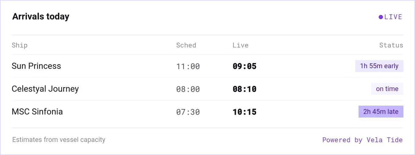
ARRIVALS BOARD
Today's calls for one port at a glance, scheduled time against live ETA, with early and late flagged. The everyday embed for a tourism portal, a municipality page, or a lobby screen.
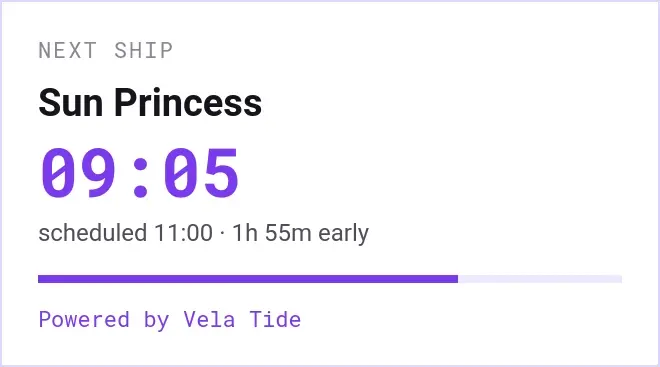
NEXT ARRIVAL
One ship, one number: when it actually gets in. The compact tile for a taverna's site, a taxi rank display, or a sidebar where only the next arrival matters.
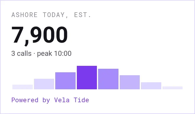
VISITORS ASHORE
A single live estimate of how many passengers are in town today, with the shape of the day beside it. For anyone who staffs, stocks, or stages around the crowd.
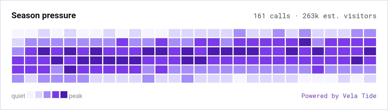
SEASON PRESSURE
The whole season in one band, day by day, quiet to peak. The citable view for press, civic groups, and destination reports, with methodology published.
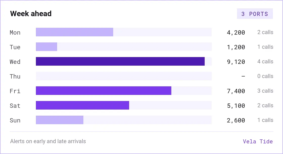
WEEK AHEAD
Seven days of calls and estimated crowd across every port you follow, ranked by pressure. For agents, tour operators, and shuttle firms who plan more than one town.
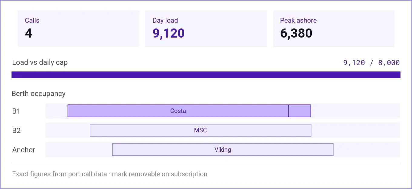
CAP AND BERTH
Declared day load against the port's cap, peak ashore, and berth occupancy with conflicts flagged. The port operations embed, running on the port's own call data.
free · with attribution
Public dashboards, KPIs and route views are free to embed and cite - the "Powered by Vela Tide" mark stays visible.
ALWAYS FREE FOR PRESS
Embeds in journalism are free. Methodology is public; operators have a right of reply on the record.
WHITE- LABEL FOR SUBSCRIBERS
Remove the mark and apply your own branding - included from the Tide Network tier, an add-on on Tide Core.
Embeddable widgets are rolling out now. The examples above are previews built with sample data — fictional operators and routes, for illustration only. Tell us the country, town, port, or operator you'd like to show and we'll set you up as they go live.
Want to start with one port?
If a port is not ready to subscribe, start with a single-port pilot: one cruise season, a fixed scope, and a fixed fee scoped under the direct-award threshold. We stand up the public board from AIS and a public schedule in under two weeks, add the port-operations layer once the port shares its call data, then transition onto a Tide Port subscription when you are ready. The public layer can go live immediately, with no port sign-off required.
FREQUENTLY ASKED QUESTIONS?
HOW DOES SHIP TRACKING WORK WITHOUT INSTALLING ANYTHING?
Every passenger vessel broadcasts AIS by international mandate. We receive it from global AIS networks, identify your calling ships automatically, build the baseline from the published schedule, and start measuring deviation. No onboard hardware and no cooperation from the cruise line.
ARE THE PASSENGER NUMBERS EXACT?
On the free public board, no, and we say so on every view. Visitors ashore is an estimate from each vessel's published capacity, which is enough to plan a shop or a taxi rank around.
Exact declared passengers per call, the berth plan, and the hour-by-hour ashore forecast come from the port's own data. The public picture exists either way. The only question is whether it runs with the port's numbers or around them.
DO WE NEED THE PORT'S COOPERATION TO START?
Not for the public layer. Live arrivals, deviation, alerts, and the visitors-ashore estimate all run on AIS and public schedules. The exact cap, berth, and ashore-flow layer is the part that uses the port's own call data.
WHAT SCHEDULE DATA DO YOU NEED?
A call list: date, ship name, scheduled arrival and departure, berth or anchorage, and expected passengers. Excel or CSV is enough for a first pilot. The live timing is ours, derived from AIS.
DOES THIS REPLACE OUR BERTH OR TERMINAL SYSTEM?
No. Tide is read-only and informational. We do not allocate berths or run terminal operations. We provide the independent measurement, the forecast, and the record, and can feed your existing systems.
HOW DO YOU HANDLE THE DAILY CAP?
We compute the declared day-load against the port's cap or coordination threshold and warn forward when a scheduled day, or a slip into the next day, would push it over. The cap enforcement view is part of the Tide Port layer.
CAN PASSENGERS AND THE PUBLIC SEE IT?
Yes. The free public board is the point: the town, merchants, tour operators, and press all see live arrivals and the estimated crowd ashore, with methodology published and a right of reply for the port.
WHICH PORTS DO YOU COVER?
We start in the Mediterranean and can add any cruise port within about two weeks: the fleet is a closed set of a few hundred ships already in our stream, so a new port is a schedule baseline plus configuration.
CAN WE EXPORT OUR DATA?
Yes. CSV, JSON, and NGSI-LD exports are all available. No lock-in, your data stays yours.
WHAT ABOUT EMISSIONS AND SHORE POWER?
Tide measures dwell time and at-berth load per call, the data base for shore-power sizing and the OPS and FuelEU Maritime readiness case. We supply the measurement and the record, not the berth hardware.
READY?
VELA CONTEXT DATA HUB · ONE SHARED DATA LANGUAGE FOR SMART CITIES · EU OPEN STANDARDS (NGSI-LD) · YOUR INFRASTRUCTURE, YOUR RULES