
PRODUCTS
VELA PULSE
MULTI- MODAL PERFORMANCE INTELLIGENCE
BUSES, TRAINS, FERRIES, AND FLIGHTS. ONE SUBSCRIPTION. EVERY DELAY, ACCOUNTED FOR.
WHAT VELA PULSE DOES
Vela Pulse turns live mobility data into operator-grade visibility across every mode. Real-time vehicle and vessel tracking, delay calculations, on-time-performance dashboards, headway adherence, airport punctuality monitoring, and historical archive - all served as a multi-tenant SaaS, with public widgets and a developer API on top.
Buses and trains via GTFS-RT. Ferries and water transit via AIS. Flights via ADS-B. One platform, every mode, every route, every delay accounted for.
Built on the Vela Context Data Hub and the ETSI NGSI-LD open standard. Designed for operators, authorities, maritime regulators, and airports that need ongoing performance visibility without a custom build.
One subscription. Every route. EVERY AIRPORT. EVERY MODE. Every delay, accounted for.
WHO VELA PULSE IS FOR
MUNICIPAL OPERATORS
Small-city bus and tram services running 5–50 vehicles.
REGIONAL OPERATORS
Mid-size networks with 50–500 vehicles needing depth.
MULTI-OPERATOR PTAs
Regional and national authorities coordinating many operators.
FERRY OPERATORS &
PORT AUTHORITIES
Island lifeline services, coastal routes, river ferries - monitored via AIS.
MARITIME REGULATORS
Ministries and agencies overseeing subsidized ferry routes and PSO compliance.
AIRPORT OPERATORS &
CONCESSIONAIRES
Flight delay dashboards for terminal operations, retail staffing, and ground transport coordination.
RAILWAY COMPANIES
Competitive intelligence on parallel air routes. Real-time flight disruption monitoring on your corridors.
TOURISM AUTHORITIES
Live transit, ferry, and flight status on regional mobility portals.
MOBILITY CONSULTANCIES
Historical data for planning, reporting, and corridor analysis.
If you have a GTFS-RT feed, operate AIS-equipped vessels, or run an airport - Vela Pulse is for you.
KEY CAPABILITIES
LIVE VEHICLE, VESSEL &
FLIGHT TRACKING
Public-facing live map for buses, trains, ferries, and airport flights. Embeddable on your website.
DELAY CALCULATION
Schedule and headway adherence. On-time performance across all modes.
KPI dashboards
Operator, dispatch, and management views. Route rankings. Airport punctuality. Mode comparisons.
HISTORICAL ARCHIVE
Every vehicle position. Every trip update. Every vessel track. Every flight. Retained.
Public delay widgets
and dashboards
Shareable links. Embeddable iframes. Public accountability reports.
Developer API
Query historical and real-time data programmatically.
AIS MARITIME TRACKING
Automatic vessel identification, port arrival detection, and ferry delay monitoring via AIS - no hardware required.
AIRPORT FLIGHT DELAY
MONITORING
All airlines at your airport. Delay rankings. Cancellation rates. Terminal-level aggregation. No airline cooperation needed - ADS-B data is broadcast publicly.
CROSS-DOMAIN INTEGRATION
Combine transit with weather, parking, air quality, events.
MULTI-LANGUAGE
DE, IT, EN, SL, HR, CS, FR, EL by default.
HOW IT WORKS
1
You publish
(or already publish)
a GTFS-RT feed,
OPERATE VESSELS,
OR RUN AN AIRPORT
Vela Pulse ingests GTFS-RT feeds on day one. For ferries, we track vessels automatically via AIS. For airports, we monitor flights via ADS-B. No integration project, no onboard hardware, no airline cooperation required.
2
We host the live data
and historical archive
Vehicle positions, trip updates, vessel tracks, and flight data are stored on the Vela Context Data Hub. NGSI-LD-native, queryable via API, exportable as GTFS-RT, NeTEx, or CSV.
3
You get dashboards,
widgets, and APIs
Live map for your website, KPI dashboards for your team, public reliability reports for your passengers, developer API for everyone else.
4
We expand from there
Weather correlation, predictive forecasting, multi-operator benchmarking, cross-modal analytics - added as your needs grow.
From feed to dashboard in under a week. From AIS to ferry dashboard in two weeks. Airport monitoring from day one.
PRICING
PULSE CORE
€299 per month
+ €15 per standard route per month
+ €40 per maritime route per month
Up to 25 routes
Single operator or single-operator authority
For small operators and municipal authorities
running one bus, tram, or ferry network.
Real-time tracking and live map -
(vehicles and vessels)
Public-facing status widget
Basic delay dashboards
Basic on-time-performance dashboards
90 days of history
Developer API (50,000 calls / month)
-
Support
Email support (Business hours)
PULSE PRO
€499 per month
+ €25 per standard route per month
+ €60 per maritime route per month
+ €200 per airport per month
Up to 150 routes and/or airports
Multi-operator authority or regional consortium with multiple lines, regions, or modes.
For mid-size operators, authorities, and
airports needing historical depth
and predictive analytics.
Everything in Core
Full history (unlimited retention)
Predictive delay forecasting -
(statistical models)
Service-quality reports and trend analysis
Airport airline punctuality rankings and
terminal dashboards
Custom KPI dashboards
Developer API (250,000 calls / month)
Support
Priority support (Business hours)
PULSE NETWORK
€999 per month
+ €20 per standard route per month
+ €50 per maritime route per month
+ €150 per airport per month
Unlimited routes and airports
For PTAs, ministries, airport groups, and
authorities managing
multiple operators or modes.
Everything in Pro
Multi-operator and
multi-modal dashboards and benchmarking
Cross-operator, cross-modal, and
cross-airport comparisons
White-label public reporting
Developer API (unlimited)
Quarterly review session
Support
SLA and on-call
Volume discount on standard routes: €15/route for 150–500 routes. €10/route for 500+.
Volume discount on maritime routes: €40/route for 50–150 routes. €30/route for 150+.
Volume discount on airports: €100/airport for 10+.
"Active route" means a route with at least one vehicle or vessel appearing in the data stream on 5 or more days per month. "Active airport" means an airport with at least one scheduled flight per day. We count automatically - you don't report.
Don't have a standard feed? We can build a custom connector for proprietary APIs and non-standard data sources. One-time integration fee applies. Contact sales.
INTEGRATIONS
GTFS Static
Schedules, routes, stops.
GTFS-RT
Vehicle positions, trip updates, service alerts.
AIS (Automatic Identification
System)
Vessel positions, speed, course, identity - for ferries and water transit.
ADS-B (Automatic Dependent
Surveillance–Broadcast)
Flight positions, altitude, speed, callsign - for airport and aviation monitoring.
NeTEx and SIRI
Via converter.
Custom AVL feeds
On request, integration time 1–3 weeks.
NGSI-LD Smart Data Models
Mobility, marine transport, and aviation domains.
Webhook-based event
streaming
For downstream systems.
PUT LIVE TRANSPORT PERFORMANCE ON YOUR OWN PAGE
Vela Pulse views are designed to embed — on a city portal, a hotel website, a newsroom article, or a lobby screen. One line of HTML, always up to date, no maintenance.
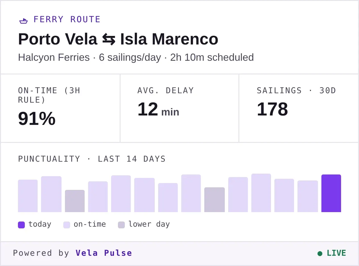
Route View
One route's punctuality at a glance - on-time rate, average delay, and a recent trend. The everyday embed for a municipality page or a news article.
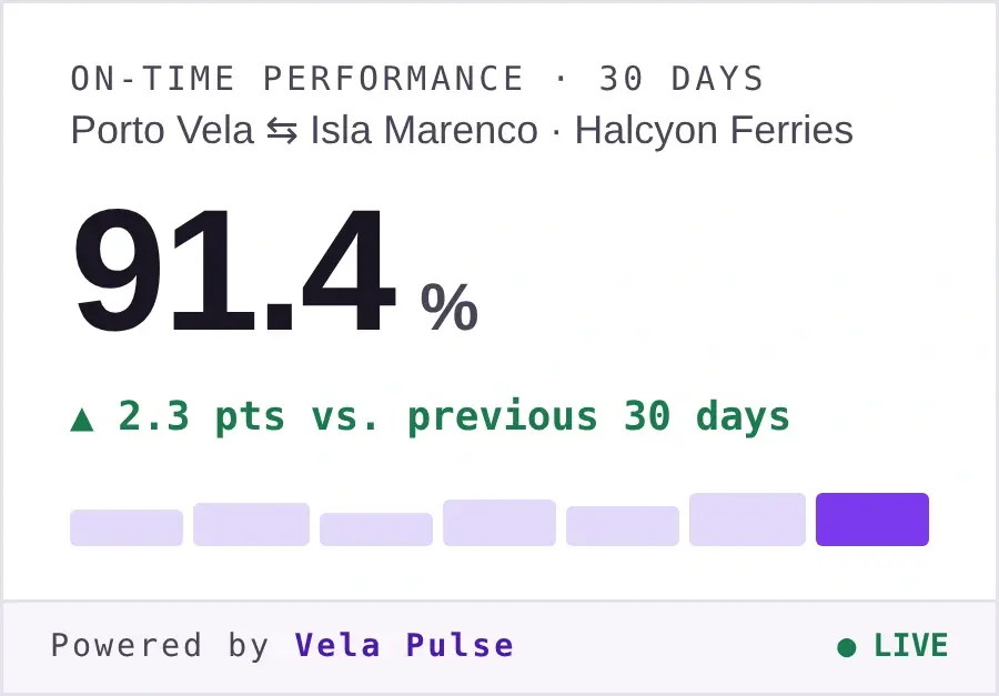
Single KPI
One live number - on-time %, average delay, today's disruptions — for a sidebar, a report, or a slide.
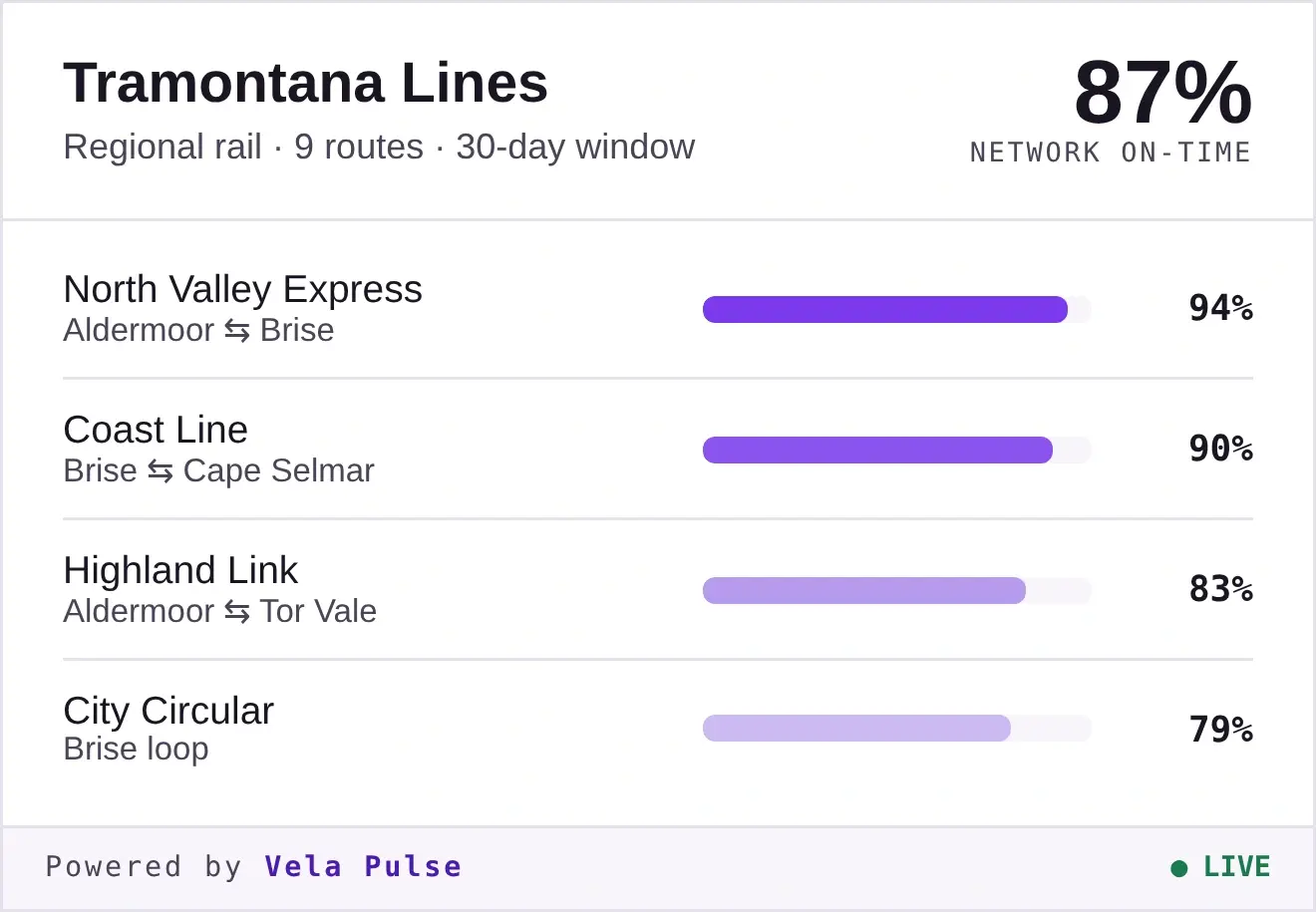
Operator view
A whole network's reliability, route by route - for an operator's own site or an authority's transparency portal.
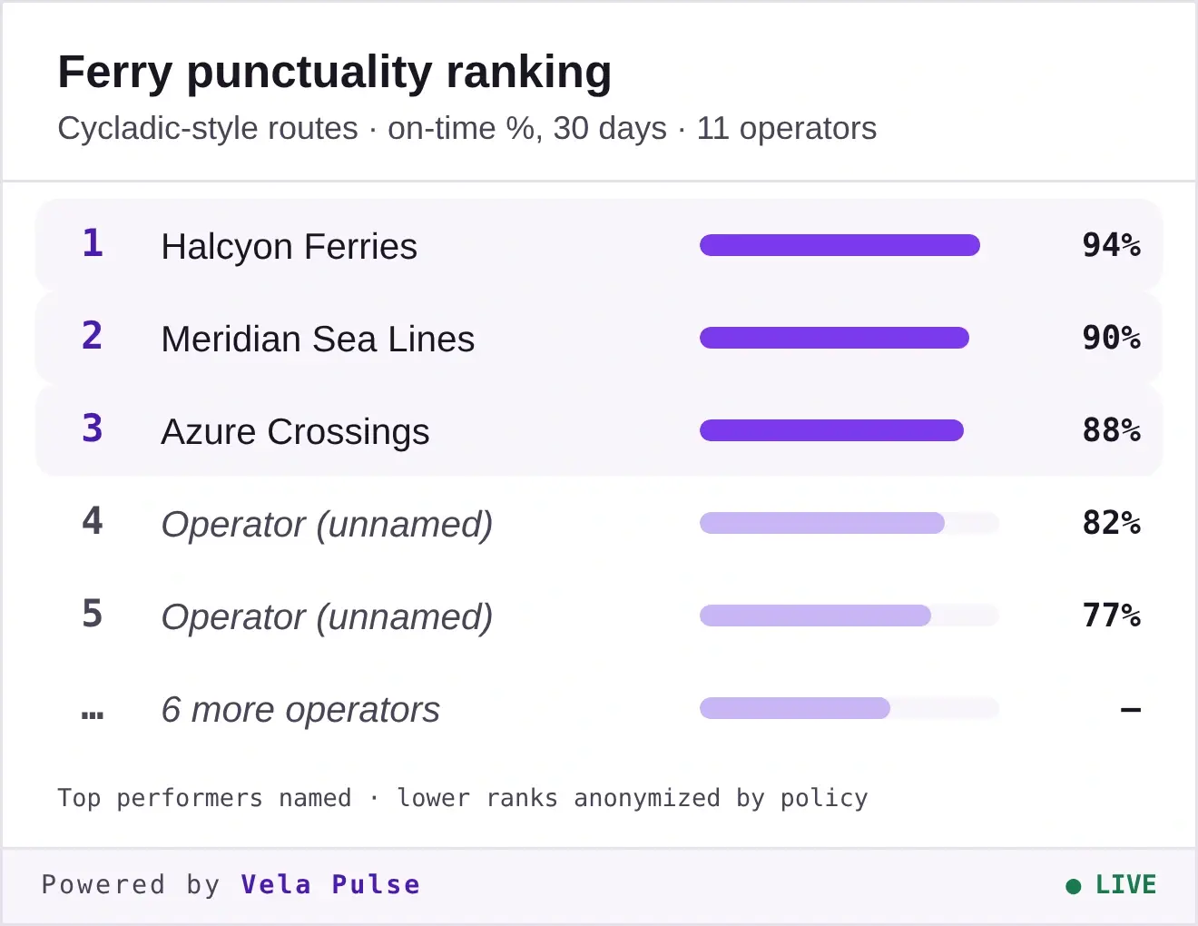
Leaderboard
Ranked performance across operators. Top performers named; lower ranks anonymised by policy - accountability with fairness built in.
Reliability badge
A compact inline mark - drop it into a footer, a route page, or a README. Small, shareable, always current.
free · with attribution
Public dashboards, KPIs and route views are free to embed and cite - the "Powered by Vela Pulse" mark stays visible.
ALWAYS FREE FOR PRESS
Embeds in journalism are free. Methodology is public; operators have a right of reply on the record.
WHITE- LABEL FOR SUBSCRIBERS
Remove the mark and apply your own branding - included from the Pulse Network tier, an add-on on Pulse Core.
Embeddable widgets are rolling out now. The examples above are previews built with sample data — fictional operators and routes, for illustration only. Tell us the country, route, or operator you'd like to show and we'll set you up as they go live.
Need a One-Operator Deployment First?
If your operator doesn't have GTFS-RT yet - or if you want a fully consultative one-deployment project before subscribing to Pulse - start with the Mobility Starter Pack. We'll get your data publishing first, then transition you onto Pulse when you're ready. For ferry operators, we handle everything: AIS setup, schedule onboarding, port geofences. For airports, monitoring starts from day one - no setup on your side.
FREQUENTLY ASKED QUESTIONS?
DO I HAVE TO PUBLISH MY GTFS-RT DATA PUBLICLY?
No. We host private feeds with the same SLA as public ones. Your data stays yours.
WHAT IF MY GTFS-RT FEED IS MESSY OR PARTIAL?
Pulse runs feed validation continuously and reports issues. We can also help you clean and improve your feed as part of the onboarding.
CAN I EXPORT MY DATA?
Yes. CSV, JSON, NGSI-LD, and original GTFS-RT exports are all available. No lock-in.
DOES THIS REPLACE MY SCHEDULING OR DISPATCH SYSTEM?
No. Pulse is read-only and informational. We're not in the business of telling drivers or captains what to do.
WHAT ABOUT REGULATORY KPI REPORTING?
Pulse is informational by design. If you need formal regulatory submission, we can quote it as a separate scope. We don't bundle this into the standard product.
HOW DOES FERRY TRACKING WORK WITHOUT INSTALLING ANYTHING?
Every passenger vessel broadcasts AIS (Automatic Identification System) by international mandate. We receive this data from global AIS networks - no onboard hardware, no integration with the operator's systems. We identify your vessels automatically, build the schedule from public timetables, and start measuring delays.
HOW DOES AIRPORT MONITORING WORK WITHOUT AIRLINE COOPERATION?
Every commercial aircraft broadcasts ADS-B (Automatic Dependent Surveillance–Broadcast). We receive this data from open ADS-B networks, match flights to published schedules using callsigns, and compute delay automatically. No airline cooperation, no airport integration required. You get a complete punctuality picture from day one.
WHAT'S THE DIFFERENCE BETWEEN STANDARD ROUTES, MARITIME ROUTES, AND AIRPORTS?
Standard routes use automated GTFS-RT or SIRI feeds - plug and play. Maritime routes require AIS vessel tracking, manual schedule monitoring, and port geofence maintenance. Airports use ADS-B flight tracking with automatic schedule matching. Each rate reflects the data complexity and service level involved.
CAN I MONITOR BUSES, FERRIES, AND FLIGHTS IN ONE SUBSCRIPTION?
Yes. Pulse supports multi-modal monitoring. Add standard routes, maritime routes, and airports to the same subscription. You'll see everything in one dashboard.
DO YOU COVER MY COUNTRY'S FERRIES?
We currently track ferries in the Mediterranean (Greece, Croatia, Italy), Northern Europe (Netherlands, Norway, Nordics), and can expand to any maritime region within two weeks. Contact us for your specific area.
WHICH AIRPORTS CAN I MONITOR?
Any airport with scheduled commercial service in Europe - and most airports worldwide. ADS-B coverage is global. If a commercial flight lands there, we can track it.
READY?
VELA CONTEXT DATA HUB · ONE SHARED DATA LANGUAGE FOR SMART CITIES · EU OPEN STANDARDS (NGSI-LD) · YOUR INFRASTRUCTURE, YOUR RULES